Photo Corners headlinesarchivemikepasini.com
![]()
A S C R A P B O O K O F S O L U T I O N S F O R T H E P H O T O G R A P H E R
![]()
Enhancing the enjoyment of taking pictures with news that matters, features that entertain and images that delight. Published frequently.
Phase One, Quantum, Trimble Combine for Aerial Surveying Solution


6 November 2023
Phase One, in collaboration with Quantum Systems and Trimble, has announced a next-generation drone surveying product for the modern surveyor. The Phase One P5 128-megapixel camera, designed for survey grade applications, has been integrated into the Quantum Systems Trinity Pro mapping drone and the Trimble Business Center surveying workflow.
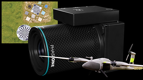
New Drone Surveying Solution. The Phase One P5 camera flanked by an UAV surveying image and the Trinity Pro drone.
A drone survey uses a drone or unmanned aerial vehicle to capture data from the sky with downward-facing cameras from different angles, tagging each image with coordinates.
Photogrammetry combines those images into detailed 2D and 3D maps. These maps can also be used to find highly-accurate distances or volumetric measurements.
Unlike manned aircraft or satellite imagery, drones can fly at a much lower altitude, making the generation of high-resolution, high-accuracy data much faster, less expensive and independent of atmospheric conditions like cloud cover. And it's five times faster than land-based surveying.
DETAILS
The Phase One P5 addresses the speed, weight and data quality shortcomings of conventional cameras for unmanned aerial vehicles.
The Quantum Systems Trinity Pro, with over 75,000 flight hours, features a ground speed of up to 22 m/s while maintaining safe operational altitudes ranging from 60 to 120 meters AGL, enabling the rapid surveying of large-scale areas with just a single flight.
Designed as an end-to-end surveying instrument, the Trinity Pro and Phase One P5 solution seamlessly integrates into the Trimble Business Center workflow, setting a new standard for engineering surveying, the companies said.
PANEL
At Trimble Dimensions 2023 today from 4:20 to 5:30 PST, Joe Blecha from Trimble Inc., Robert Leake from Quantum Systems and Lau N_rgaard from Phase One will discuss "the world's first true survey-grade end-to-end UAV solution."
Phase One, Quantum Systems and Trimble Unveil Groundbreaking Survey Grade UAV Solution with Phase One P5 Camera Launch
Join us at Trimble Dimensions Nov. 6 in Titian 2202 & 2203 at 4:30 p.m. or at booth #834 & discover the new standard for UAV-based aerial engineering surveying
LAS VEGAS, Nev. -- Phase One, pioneer in medium- and large-format digital cameras and imaging systems proudly announces the next-generation instrument for the modern surveyor in collaboration with Quantum Systems and Trimble. The new state-of-the-art Phase One P5 128-megapixel camera, purpose-built for survey grade applications, has been seamlessly integrated into Quantum Systems' flagship Trinity Pro mapping drone and the leading surveying workflow Trimble Business Center.
Challenges in the fields of architecture, construction and engineering:
The surveying and construction industry confronts a wide range of challenges, including the critical aspects of time constraints, resource limitations, project requirements and the potential for costly fines due to project delays. Traditional surveying methods have proven to be time-consuming to reach the statistical confidence needed in data quality, which further intensifies the challenge of monitoring construction progress in a timely manner. Delayed delivery of critical projects not only results in substantial financial penalties but also hampers overall industry progress.
Accurate surveys play a critical role in construction projects and architectural design, whether it's during the construction phase or in the post-completion monitoring stage. However, current UAV-based surveying solutions have often fallen short in capturing survey-grade quality data, leaving a critical gap in meeting industry demands.
Unmatched survey-grade accuracy with the world's first true end-to-end UAV solution:
In the realm of specialized camera systems, the Phase One P5 has been meticulously crafted to address the shortcomings of conventional cameras for UAVs in terms of speed, weight and data quality. Purpose-built for aerial surveying via drone, the camera stands as the world's pioneering solution, consistently delivering the highest resolution and accuracy, along with industry-standard metrical calibration.
Phase One P5 enhances productivity and addresses the industry's surveyor shortage by being deployed in conjunction with Quantum Systems Trinity Pro. With a proven track record of over 75,000 flight hours, The Trinity Pro ensures reliability and reduces maintenance requirements, allowing surveyors to focus on their core tasks. Quantum System's Trinity Pro UAV facilitates high productivity missions with a ground speed of up to 22 m/s while maintaining safe operational altitudes ranging from 60 to 120 meters AGL, enabling the rapid surveying of large-scale areas with just a single flight.
Designed as an end-to-end surveying instrument, the Trinity Pro and Phase One P5 solution seamlessly integrates into the Trimble Business Center workflow, setting a new standard for engineering surveying. The modern surveyor will benefit from state-of-the-art technology to improve productivity and increase profitability.
The integration of the Phase One P5 camera into Quantum Systems' Trinity Pro UAV presents an extensive range of benefits for construction engineering customers. The Phase One P5 camera integration guarantees precision, securing survey-grade data accuracy. This exceptional level of detail and accuracy is paramount for construction projects, fostering confident decision-making while simultaneously minimizing post-processing efforts. Consequently, these features establish the joint solution as an indispensable tool for construction engineering professionals, streamlining large-scale data collection and delivering unparalleled efficiency.
"We are proud to introduce a pioneering solution that not only addresses the profound challenges faced by the surveying and construction industry but also sets new benchmarks for efficiency and precision," said Robert Leake, Head of Commercial Sales at Quantum Systems. "Our collaboration with Phase One and Trimble has yielded a game-changing survey-grade UAV solution. Achieving this level of quality, detail and accuracy within a fixed-wing platform is a first in the industry. We're opening new horizons for engineering surveying professionals and we're excited to be at the forefront of this revolutionary leap forward."
The new standard in UAV-based engineering surveying:
At the heart of this transformative solution for mapping and surveying professionals, the Phase One P5 camera stands as a symbol of the highest accuracy. It boasts an impressive 128-Mp resolution, ensuring an extraordinary level of precision and data reliability.
"Each Phase One P5 camera undergoes factory metric calibration and is supplied with a calibration certificate. When integrated with the Trinity Pro system, the Phase One P5 swiftly and accurately covers large survey areas, resulting in significant time and cost savings compared to traditional mapping and surveying methods," states Michael Messerschmidt, Director Product Management Unmanned at Phase One.
The utilization of an electronic global shutter, combined with precisely calibrated lenses and sensor, minimizes the need for extensive post-processing and software corrections typically required to address pixel distortion, thereby ensuring the preservation of high-quality data.
With the launch of the Phase One P5 camera and the complete survey-grade UAV solution, Quantum Systems, Phase One and Trimble are opening new horizons for professionals in the field of aerial engineering surveying. This groundbreaking solution empowers surveyors to work with unmatched precision, providing data of exceptional accuracy for a wide range of applications.
For additional information on the Phase One P5 camera please visit https://geospatial.phaseone.com/drone-payload/p5/